The official website of Visit Causeway Coast and Glens
En

Christie Park and Somerset

Somerset Riverside Park, Castleroe Road, Coleraine, Derry/Londonderry, BT51 3TX
the river bann
  • the river bann
  • pier on the river bann
  • sculpture on the Christie Park and Somerset route
  • sculpture at somerset riverside park
  • signage at somerset riverside park

Book Tickets Online

About

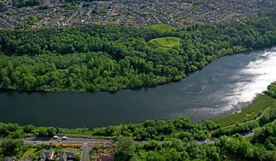
This is a pleasant 2 mile / 3.5 km long (return distance) linear riverside walk along shared-use pathways, starting in the centre of Coleraine and finishing close to The Cutts area, opposite the historic Mountsandel Fort. The walk passes through two areas of parkland managed by Causeway Coast and Glens Borough Council, hugging the Bann along its entire length.

ROUTE DESCRIPTION

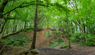
This linear walk can be walked in both directions. The starting point for the upstream walk is the car park in Christie Park, accessed off Strand Road.  Follow the riverside pathway upstream towards Sandelford Bridge (away from the town centre old bridge). Having passed under the bridge, take the shared-use path to the left and proceed along this riverside pathway until reaching Somerset Riverside Park car park, opposite Mountsandel Fort. Take time along the route to enjoy the views over the Bann and study the interpretation panels provided. Having reached the car park walkers have the option of crossing the road and further enjoying a variety of walks within Somerset Forest before returning to the starting point via the same route.  A public art sculpture entitled 'Source' and interpretation panels in this car park provide information outlining the historical significance of Mountsandel on the opposite river bank.
 

Facilities

Accessibility

  • Activities accessible for visitors with disabilities
  • Designated parking provided for guests with disabilities
  • Toilets for disabled visitors

Catering

  • Picnic Area

Establishment Features

  • Toilets

Parking & Transport

  • Car parking
  • Coach parking
  • Parking (free)

Map & Directions

What's Nearby

  1. Mountsandel Wood is the earliest known settlement of man in Ireland dating to between…

    0.18 miles away
  2. Coleraine Town Hall presides over the central shopping piazza in Coleraine. Designed by…

    1.24 miles away
  3. Situated on either side of River Bann. Mixed woodland planted 19th Century and the 1930s…

    1.3 miles away
  1. A picturesque wooded picnic area on the banks of the Lower River Bann – with an important…

    2.27 miles away
  2. Flowerfield Arts Centre is Coleraine’s dedicated arts facility, offering superb…

    4.32 miles away
  3. Between Portstewart and the mouth of the River Bann lies the golden sands and domineering…

    4.69 miles away
  4. The Blackheath Pottery is a unique pottery and café, situated between Coleraine and…

    4.73 miles away
  5. This historic estate has been in existence since 1630s, making it one of the oldest in…

    5.65 miles away
  6. Award winning beach in the heart of the resort of Portrush.

    6.08 miles away
  7. Castlerock is a 1km (0.7 mile) long stretch of beach between the sea cliffs of Downhill…

    6.09 miles away
  8. A picture-perfect seaside village in Binevenagh Area of Outstanding Natural Beauty.

    6.32 miles away
  9. East Strand Beach in Portrush is a famously golden sandy beach, with views of The…

    6.32 miles away
  10. The Arcardia includes children's feature paddling pools, play frame and sand area.…

    6.4 miles away
  11. Ballymoney’s Arts, Museum and Visitor Information Centre is well worth a visit. This…

    6.46 miles away
  12. From the Mesolithic to Motorcycles, through rebellion and war, politics, industry, sport…

    6.51 miles away
  13. Visitors to the area can explore this unique studio & gallery space featuring the work of…

    6.53 miles away
Previous Next

Related

aerial view of Mountsandel WoodMountsandel Wood, Northern IrelandMountsandel Wood is located on the eastern bank of the River Bann on the southern outskirts of Coleraine. Circular trails enable the visitor to view the Anglo Norman Fort and the Mesolithic excavation site, site to the earliest known human settlement in Ireland.

section of waymarked trail through Somerset ForestSomerset Forest, Northern IrelandSomerset Forest is located on the south western boundary of Coleraine, accessed from Castleroe Road. Within the forest there is a range of walks of varying lengths and degrees of difficulty.

Map & Directions

View Maps and Visitor Guides
View of what Causeway Coast and Glens has to offer and some of the best things to see and do during a visit.
E-newsletter sign up
Sign up for the Causeway Coastal Route newsletter for inspiration and travel tips.
Back to Top

Tourism Northern Ireland

Don't Miss