The official website of Visit Causeway Coast and Glens
En

Magilligan Point Nature Reserve

Magilligan Point, Point Road, Limavady, County Londonderry, BT49 0LP
Product Image
  • Product Image
  • Product Image
  • Product Image
  • Product Image
  • Product Image
  • Product Image
  • Product Image
  • Product Image

Book Tickets Online

About

Magilligan Point is the tip of one of the largest sand dune systems in the British Isles. The way the coastline constantly changes has generated a lot of interest and is one of the main reasons why the site has been declared a nature reserve. Many metres of sand dune can disappear in a sudden winter storm in what may appear to be severe erosion. However, the cycling of sand around the foreland and out to the Tunns Bank has been going on for centuries.

The dunes have advanced and retreated again many times. In the last 20 years, more than 50 scientific papers have been published about Magilligan and the story is still being unravelled. In the summertime, a wide variety of wild flowers add a splash of colour to the dunes. Harebells and bird's-foot Trefoil are followed later by Thyme and Pyramidal Orchids. On warm days, butterflies such as the Common Blue or Meadow Brown are seen in abundance and visitors may also be able to spot the rare six-spot Burnet moth.

For birdwatchers, Magilligan Point offers good views of seabirds using the narrows and in winter, migrating waders and wildfowl.

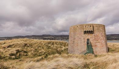
The Martello Tower located within the Magilligan Nature Reserve was built in the early 1800s, as much for defence against American privateers as against the threat from France. It was equipped with a 24 pounder cannon and a garrison of 13.

Facilities

Attraction Facilities

  • Open Evenings
  • Open Mondays
  • Open Sundays

Parking & Transport

  • On site parking

Provider Preferences

  • Free (parking charges may apply)

Add Magilligan Point Nature Reserve to your Itinerary

Close window

Call direct on:

Tel+44 (0) 28 7035 9977

Map & Directions

Opening Times

* The Nature Reserve is always open.

A Ministry of Defence (MOD) firing range is adjacent to the nature reserve and visitors should note that access restrictions along the beach can apply. Please read local signs for safety instructions.

What's Nearby

  1. A well preserved Martello Tower at Magilligan Point, an important historical site in…

    0.12 miles away
  2. Benone Strand, multiple recipient of the European Blue Flag and Seaside Award, is a…

    3.87 miles away
  3. Gortmore's superb Viewpoint situated on the Bishop's Road on the Binevenagh Loop, as part…

    4.51 miles away
  1. An inscribed stone cross at Duncrun marks the site of St Patrick's Monastery and the…

    4.69 miles away
  2. Picturesque riverbank area overlooking the River Roe beneath Binevenagh Mountain – a…

    5.56 miles away
  3. Binevenagh is a tranquil area where the sights of Lough Foyle and Donegal can be seen on…

    5.66 miles away
  4. Binevenagh is renowned for its impressive cliffs that provide a perfect alpine cliff…

    5.69 miles away
  5. Downhill is a golden sandy beach stretching from Downhill Cliffs in the east towards…

    5.88 miles away
  6. Hezlett’s picturesque thatched cottage exterior hides a fascinating early timber frame…

    6.38 miles away
  7. Mussenden Temple is located in the beautiful surroundings of Downhill Demesne near…

    6.38 miles away
  8. A picture-perfect seaside village in Binevenagh Area of Outstanding Natural Beauty.

    6.9 miles away
  9. Castlerock is a 1km (0.7 mile) long stretch of beach between the sea cliffs of Downhill…

    7.23 miles away
  10. Have you ever wondered how Broighter Gold Rapeseed Oil make their award-winning Liquid…

    8.34 miles away
  11. Between Portstewart and the mouth of the River Bann lies the golden sands and domineering…

    9.43 miles away
  12. Small village on the main route from Limavady to Derry, Greysteel hosts The Vale Centre,…

    9.71 miles away
  13. Rough Fort, on the Limavady to Ballykelly road, is a remarkable earthwork construction…

    9.73 miles away
Previous Next

Related

Magilligan Martello Tower, LimavadyA well preserved Martello Tower at Magilligan Point, an important historical site in Northern Ireland, built during the Napeolonic Wars marks the entrance to Lough Foyle.

Map & Directions

Road Directions

Directions from Town:From either Coleraine or Limavady follow road signs for Magilligan Ferry along the Causeway Coastal Route. Drive past the ferry terminal and Martello Tower appears on your left hand side. Approx 16km north of Limavady. Car park at end of public road.

View Maps and Visitor Guides
View of what Causeway Coast and Glens has to offer and some of the best things to see and do during a visit.
E-newsletter sign up
Sign up for the Causeway Coastal Route newsletter for inspiration and travel tips.
Back to Top

Tourism Northern Ireland

Don't Miss