The official website of Visit Causeway Coast and Glens
En

Avish To Eagle's Hill

Gortmore View Point, Bishops Road, Limavady, Derry/Londonderry, BT49 0LG
Avish to Eagle's Hill
  • Avish to Eagle's Hill
  • Avish to Eagle's Hill
  • Avish to Eagle's Hill
  • Avish to Eagle's Hill
  • Avish to Eagle's Hill
  • Avish to Eagle's Hill

Book Tickets Online

About

STARTING POINT
To get to the trail head from Limavady - The Bishop’s Road begins a few miles north east of Limavady town. Take the Windy Hill Road (B201) and turn left onto the Bishop’s Road; Gortmore View Point is approximately 5 miles from this junction.

To get to the trail head from Castlerock/Downhill – Follow Mussendun Road (A2) signed as Causeway Coastal Route. When you descend into Downhill turn left onto Bishop’s Road as it rises steeply. Look for the brown and white signs for Binevenagh Scenic Loop and Gortmore. The viewpoint is approximately 2.5 miles along this road.

ROUTE DESCRIPTION
From Gortmore View Point follow the path past the basalt bench as it descends towards a stile and way marker in front of you. Crossing the stile you are now in the townland of Avish; descend through the field keeping the fence on your left. This section is steep in places and can be slippery at times. After 600 metres you should find a stile over a fence at IC 719 347 which will then lead you across a rushy field. Head in a north easterly direction for a further 600 metres to IC 725 349 where you step across a stream before climbing the bank to meet another stile and fence.

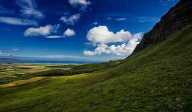
Continue north east, and as Eagle Hill comes into view on your right, veer towards the fence and the cliff line on your left. Follow the fence which now is constructed in an old stone wall. Look over Benone Strand and the distinctive sweep of the beach towards Magilligan Point comes into view. Look down over Umbra nature reserve and the expanse of beach.

By now more of the Causeway Coast opens up before you. Meet another stile at IC 729 355 and follow the stone wall to where it curves around above one of the many waterfalls along the Seacoast Road.

When you’ve had your fill of the view turn south and ascend through the field keeping the stream feeding the waterfall on your left. Pass through an old stone boundary wall at IC 732 353 continuing south to meet the Bishop’s Road.

Carefully cross the stile over a stone wall at IC 732 350 to return to the public road. Turn right to ascend the Bishop’s Road for 2 kms back to Gortmore Viewpoint or left for Downhill. Please note this walk can be combined with the Gortmore to Hells Hole route to make a 5 mile long route.

As you descend through the field take the time to look towards Inishowen, Magilligan Point and Benone Strand. You may be joined by some of the cliff nesting birds that nest below you such as fulmar and peregrine or by a paraglider above you.

Look out for feral goats which roam around the area, you’re sure to smell them before you see them, especially the big billy! Looking to the east there are superb views towards Mussenden, the Downhill Estate and the Bann Estuary.

Facilities

Parking & Transport

  • Car parking
  • Parking (free)

Map & Directions

Opening Times

Open Christmas
Open New Year

What's Nearby

  1. Gortmore's superb Viewpoint situated on the Bishop's Road on the Binevenagh Loop, as part…

    0 miles away
  2. Binevenagh is renowned for its impressive cliffs that provide a perfect alpine cliff…

    1.21 miles away
  3. Benone Strand, multiple recipient of the European Blue Flag and Seaside Award, is a…

    1.33 miles away
  1. Downhill is a golden sandy beach stretching from Downhill Cliffs in the east towards…

    2.53 miles away
  2. Mussenden Temple is located in the beautiful surroundings of Downhill Demesne near…

    2.84 miles away
  3. Hezlett’s picturesque thatched cottage exterior hides a fascinating early timber frame…

    2.84 miles away
  4. Binevenagh is a tranquil area where the sights of Lough Foyle and Donegal can be seen on…

    2.87 miles away
  5. An inscribed stone cross at Duncrun marks the site of St Patrick's Monastery and the…

    2.91 miles away
  6. A picture-perfect seaside village in Binevenagh Area of Outstanding Natural Beauty.

    3.44 miles away
  7. Castlerock is a 1km (0.7 mile) long stretch of beach between the sea cliffs of Downhill…

    3.83 miles away
  8. Picturesque riverbank area overlooking the River Roe beneath Binevenagh Mountain – a…

    3.86 miles away
  9. A well preserved Martello Tower at Magilligan Point, an important historical site in…

    4.51 miles away
  10. Magilligan Point is the tip of one of the largest sand dune systems in the British Isles.…

    4.51 miles away
  11. Between Portstewart and the mouth of the River Bann lies the golden sands and domineering…

    6.06 miles away
  12. Flowerfield Arts Centre is Coleraine’s dedicated arts facility, offering superb…

    6.86 miles away
  13. Have you ever wondered how Broighter Gold Rapeseed Oil make their award-winning Liquid…

    6.91 miles away
Previous Next

Related

Binevenagh Mountain WalkBinevenagh Mountain Walk, LimavadyThis short walk along forest road and through coniferous forest with a steep section leading to the cliffs of Binevenagh offers panoramic views over Lough Foyle, the Roe Valley, Inishowen and to the west coast of Scotland.

Mannanan Mac Lir statue at Gortmore ViewpointGortmore to Hell's Hole, Northern IrelandGortmore to Hell's Hole offers a short upland walk along a section of the North Sperrins Way/Ulster Way offering great views to Binevenagh, Lough Foyle, Inishowen, the Causeway Coast and to Islay and Jura.

Map & Directions

View Maps and Visitor Guides
View of what Causeway Coast and Glens has to offer and some of the best things to see and do during a visit.
E-newsletter sign up
Sign up for the Causeway Coastal Route newsletter for inspiration and travel tips.
Back to Top

Tourism Northern Ireland

Don't Miss