The official website of Visit Causeway Coast and Glens
En

Binevenagh Mountain Walk

Leighery Road , Limavady, Derry/Londonderry, BT49 0LL
Binevenagh Mountain Walk
  • Binevenagh Mountain Walk
  • Binevenagh Mountain Walk
  • Binevenagh Mountain Walk
  • Binevenagh Mountain Walk
  • Binevenagh Mountain Walk
  • Binevenagh Mountain Walk

Book Tickets Online

About

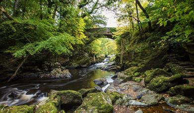
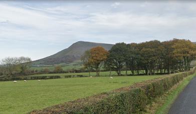
Binevenagh Mountain is one of the most distinctive headlands along the Causeway Coast. This short walk along forest road and through coniferous forest with a steep section leading to the cliffs of Binevenagh offers panoramic views over Lough Foyle, the Roe Valley, Inishowen and to the west coast of Scotland. Extended routes are available.

Park up on Leighry Road (C 703 313) adjacent to a sharp bend. Opposite is a gate leading into the forest, follow this path and take the first track to the left. Follow this uphill for 1.5 KM, turn right onto forest road and head for the summit of Binevenagh. Pass the east side of the trout stocked artificial lake, then head NW towards the cliff edge.

Panoramic views from the summit stretch for miles. On a good day you'll be rewarded with views to Inishowen and the Causeway Coast as far as Knocklayd at Ballycastle and beyond to the Scottish isles of Islay and Jura. If the conditions are right gliders from Ulster Gliding Club will fill the skies above not to mention the bird life soaringoff the cliffs.. The surrounding slopes are home to a number of rare alpine plants and birds. Follow the path NW down to the forest, when you arrive at a track turn right and you will soon be back at the start.
 

Facilities

Leisure Facilities

  • Fishing

Parking & Transport

  • Car parking
  • Parking (free)

Map & Directions

What's Nearby

  1. Binevenagh is a tranquil area where the sights of Lough Foyle and Donegal can be seen on…

    1.17 miles away
  2. An inscribed stone cross at Duncrun marks the site of St Patrick's Monastery and the…

    1.55 miles away
  3. Gortmore's superb Viewpoint situated on the Bishop's Road on the Binevenagh Loop, as part…

    1.7 miles away
  1. Binevenagh is renowned for its impressive cliffs that provide a perfect alpine cliff…

    2.18 miles away
  2. Picturesque riverbank area overlooking the River Roe beneath Binevenagh Mountain – a…

    2.29 miles away
  3. Benone Strand, multiple recipient of the European Blue Flag and Seaside Award, is a…

    2.95 miles away
  4. Downhill is a golden sandy beach stretching from Downhill Cliffs in the east towards…

    4.09 miles away
  5. Hezlett’s picturesque thatched cottage exterior hides a fascinating early timber frame…

    4.3 miles away
  6. Mussenden Temple is located in the beautiful surroundings of Downhill Demesne near…

    4.3 miles away
  7. A picture-perfect seaside village in Binevenagh Area of Outstanding Natural Beauty.

    4.88 miles away
  8. Magilligan Point is the tip of one of the largest sand dune systems in the British Isles.…

    5.09 miles away
  9. A well preserved Martello Tower at Magilligan Point, an important historical site in…

    5.13 miles away
  10. Have you ever wondered how Broighter Gold Rapeseed Oil make their award-winning Liquid…

    5.23 miles away
  11. Castlerock is a 1km (0.7 mile) long stretch of beach between the sea cliffs of Downhill…

    5.25 miles away
  12. Small village on the main route from Limavady to Derry, Greysteel hosts The Vale Centre,…

    5.66 miles away
  13. Opened in 1842, the Limavady Union Workhouse is reported to be one of the best preserved…

    5.79 miles away
Previous Next

Related

Roe Valley Country ParkRoe Valley Country Park - walking trail, Northern IrelandRoe Valley Country Park offers a variety of routes along the riverside and through woodland. Combining legend with industrial and natural heritage, the park has great appeal.

Avish to Eagle's Hill Avish To Eagle's Hill, LimavadyMussenden, Downhill Estate and the Bann Estuary are just some of the breath taking views you can enjoy from this cliff top hike.

Mannanan Mac Lir statue at Gortmore ViewpointGortmore to Hell's Hole, Northern IrelandGortmore to Hell's Hole offers a short upland walk along a section of the North Sperrins Way/Ulster Way offering great views to Binevenagh, Lough Foyle, Inishowen, the Causeway Coast and to Islay and Jura.

Benbradagh Mountain from the North Sperrins WayNorth Sperrins Way, Northern IrelandThe North Sperrins Way is a 37 mile trail that forms part of the Ulster Way and International Appalachian Trail. The route links the Sperrin and Binevenagh Areas of Outstanding Natural Beauty through the ridge of upland overlooking the Bann and Roe Valleys.

Map & Directions

View Maps and Visitor Guides
View of what Causeway Coast and Glens has to offer and some of the best things to see and do during a visit.
E-newsletter sign up
Sign up for the Causeway Coastal Route newsletter for inspiration and travel tips.
Back to Top

Tourism Northern Ireland

Don't Miss