Book Tickets Online
About
The North Sperrins Way is a 37 mile trail that forms part of the Ulster Way and International Appalachian Trail. The route links the Sperrin and Binevenagh Areas of Outstanding Natural Beauty through the ridge of upland overlooking the Bann and Roe Valleys. A challenging walk with varied terrain, it requires appropriate clothing and equipment and some navigational skill in poor weather. Given the remote nature of the trail there are no facilities on the trail itself. It is recommended to set aside two days to complete the route.
ROUTE DESCRIPTION
Leave Dungiven via the Curragh Road, which winds its way up the southwestern face of Benbradagh for 4 kilometres. At the top of the climb is a metal gate and a junction. A detour to the summit of Benbradagh can be made by turning left here and following a track north for 800 metres as far as an abrupt right turn.
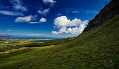
Leave the track here and make a short climb across open ground to the summit of Benbradagh. At 465m it affords a fine view over Benedy Glen, the Glenshane Pass and the high Sperrin peaks to the south. Return to the main route where you follow the American Road down the eastern flanks of Benbradagh for 1.7 kms. Look carefully for waymarker posts leading north across open terrain towards a forest plantation. The ground is generally uneven and boggy here, so it is important to follow the waymarkers carefully as there is no formal path.
After 500 metres, cross a stile to enter Lenamore Forest and then follow a track downhill for two kilometres, ignoring all turn-offs. Continue out of the forest and then turn right onto Gelvin Road. After a short distance turn left and walk north for 1.7 kms along a country road to the B64. Turn right and follow this road uphill for a few minutes (take care with traffic) and then turn left onto a track that descends past Legavannon Pot to reach Kilhoyle Road after two kilometres. Turn left onto Kilhoyle Road and follow it west for 2 kilometres. Turn right onto the Gortnarney Road for a short distance and then turn right again, following the fence line steeply to the summit of Donald’s Hill, an effort of around forty-five minutes over 1 km.
At 399m. Donald’s Hill provides a panoramic view of the Roe Valley from Lough Foyle to Dungiven. Wind turbines can be seen to the west at Altahullion Wind Farm. It is important to carefully follow the waymarker posts over the mountain’s open terrain on this section. Follow a raised track northeast over blanket bog and heather for a further kilometre to reach Temain Road. Cross a stile, turn right and follow the road for a short distance. Turn left and walk north across open mountain terrain for 1 kilometre to Rigged Hill and the ten wind turbines overlooking the Roe Valley.
Pick up a forest road and descend through Cam Forest. Cross a stile to leave the forest and follow a track west for twenty minutes as far as a junction. Turn right and walk along this surfaced track for a few minutes to the B66. Turn right and continue carefully east for a short distance. Turn left onto a track into the northern section of Cam Forest and climb steeply through the trees to a clearing with good views. Take a while to look back towards the headlands of Donald’s Hill and Benbradagh, with some of the higher Sperrins peaks beyond. Continue north into the trees, descending steadily to the A37 Coleraine-Limavady road, 3 kilometres from the B66.
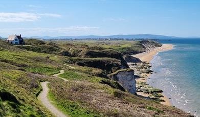
Cross the road, and taking great care, walk east along the verge for a short distance and then turn left onto a forest track leading down into Springwell Forest. Continue past Formoyle Church to the B201 – known locally as the Murder Hole Road – 4 kilometres from the A37. Turn left and take great care on this road as you proceed in a westerly direction 2 kms to a junction with the Altikeeragh Road. Turn right and follow this road for a short distance and then turn left onto a forest track. Walk west through Grange Park Wood to the television relay station on the summit of Harkins Hill and join a surfaced road for a short distance to Bishop’s Road, 5 kilometres from Altikeeragh Road. Turn right and follow Bishop’s Road north for a kilometre to a junction. To make the out-and-back detour to Binevenagh, turn left and descend along Leighrey Road for a short distance. Turn left onto a forest road and follow it to the car park and viewing area at the edge of Binevenagh’s impressive cliffs. Return along the same route to Bishop’s Road; the total distance for this detour is approximately 6 kilometres.
Continue north for 2 kilomteres along Bishop’s Road, enjoying fine views across Magilligan and Inishowen. Here you can before the road swings northeast and begins to descend more steeply. Another forty minutes takes you almost into Downhill. Look out for a right turn leading into Downhill Forest and after ten minutes turn left along the Burrenmore Road. At a sharp junction turn right into the Springbank Road then turn left again after a few minutes to enter Downhill Forest. Walk through the trees for thirty minutes to reach the A2. It’s well worth making the short detour from here to visit the Mussenden Temple (National Trust property – entrance fee from Easter to September), perched on the edge of the cliffs above Downhill and then continuing past the 12 Apostles Cottages into Castlerock. Allow an extra thirty or forty minutes for this. Otherwise simply turn right onto the A2 and follow it for twenty minutes before turning left into Sea Road and walking the short distance downhill to the finish of the Ulster Way quality section in Castlerock.