The official website of Visit Causeway Coast and Glens
En

Burnfoot

Derryork Road, Burnfoot, Dungiven, Derry/Londonderry, BT47 4NL
Arched bridge over the River Roe, Burnfoot
  • Arched bridge over the River Roe, Burnfoot
  • Old church ruins, Burnfoot
  • Old church ruins, Burnfoot
  • Picture This Trail frame in Burnfoot

Book Tickets Online

About

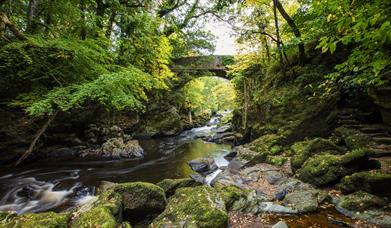
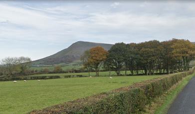
This is a short walk along the River Roe, Bovevagh and Gelvin Rivers from the village of Burnfoot through farmland and surrounded by the distinctive peaks of the Roe Valley of Benbradagh, Donald's Hill and Binevenagh. Located on the Roe Valley Scenic Route off the Causeway Coastal Route and part of the Picture This trail. This route allows for a quick fix of countryside just off the beaten track.

ROUTE DESCRIPTION

Starting from the car park on the Derryork Road, this walk follows a surfaced path along the bank of the River Roe to meet the Bovevagh River.  You will pass one of the frames that make up the Picture This trail which looks towards Benbradagh Mountain.

Crossing a small wooden bridge the trail continues downstream to eventually meet a large bridge crossing the Roe. Here you can continue on to meet a farm lane and return back towards the village or you can cross the bridge to the far bank and continue to follow the path to meet the Gelvin River and on towards the Ballyquin Road.

At this point you can return via the route you can along the river or follow the Ballyquin Road to meet the Derryork Road.  Please note that there is no footpath should you chose this option.

Facilities

Leisure Facilities

  • Fishing

Parking & Transport

  • Car parking

Map & Directions

What's Nearby

  1. A pretty village nestled between the River Roe and the Bovevagh River.

    0.1 miles away
  2. Bovevagh parish church was established in the late Middle Ages on the site of an early…

    0.92 miles away
  3. Augustinian priory with a 15th-century tomb of Cooey-na-Gall, an O'Cahan chief, who died…

    3.23 miles away
  1. Step back in time by visiting the Green Lane Museum, located at the Roe Valley Country…

    4.19 miles away
  2. Banagher Church is an impressive ruin with the nave being built around 1100. The date 474…

    4.21 miles away
  3. This scenic and tranquil park on the outskirts of Limavady offers spectacular riverside…

    4.25 miles away
  4. The ancient ruins of Tamlaght Finlagan Church and Graveyard are reputed to be the remains…

    5.62 miles away
  5. Behind every bottle of Broighter Gold Rapeseed Oil is a wealth of golden history. Our…

    5.68 miles away
  6. Opened in 1842, the Limavady Union Workhouse is reported to be one of the best preserved…

    5.86 miles away
  7. Limavady Orange Heritage Centre's aim is to promote and educate the Orange culture…

    5.99 miles away
  8. Small village on the main route from Limavady to Derry, Greysteel hosts The Vale Centre,…

    6.08 miles away
  9. Rough Fort, on the Limavady to Ballykelly road, is a remarkable earthwork construction…

    6.17 miles away
  10. Sited at Walworth is Northern Ireland's first state forest which includes a picnic area,…

    6.8 miles away
  11. Have you ever wondered how Broighter Gold Rapeseed Oil make their award-winning Liquid…

    7.7 miles away
  12. Travel 3 miles west of Garvagh town and you will begin to enter Gortnamoyagh Forest,…

    7.8 miles away
  13. A megalithic tomb, dating to the Neolitic or New Stone Age (2000-4000) is found in…

    8.96 miles away
Previous Next

Related

Frame in Burnfoot VillagePicture This: Burnfoot, DungivenA pretty village nestled between the River Roe and the Bovevagh River.

aerial view of Banagher GlenBanagher Glen, FeenyBanagher Glen is home to one of the oldest ancient oak woodlands in Ireland. Enjoy a 6 mile return walk through the steep sided glen to the spectacular Banagher Dam and Altnaheglish Reservoir. Banagher Nature Reserve is one of 50 similar reserves in Northern Ireland.

Roe Valley Country ParkRoe Valley Country Park - walking trail, Northern IrelandRoe Valley Country Park offers a variety of routes along the riverside and through woodland. Combining legend with industrial and natural heritage, the park has great appeal.

Benbradagh Mountain from the North Sperrins WayNorth Sperrins Way, Northern IrelandThe North Sperrins Way is a 37 mile trail that forms part of the Ulster Way and International Appalachian Trail. The route links the Sperrin and Binevenagh Areas of Outstanding Natural Beauty through the ridge of upland overlooking the Bann and Roe Valleys.

Map & Directions

View Maps and Visitor Guides
View of what Causeway Coast and Glens has to offer and some of the best things to see and do during a visit.
E-newsletter sign up
Sign up for the Causeway Coastal Route newsletter for inspiration and travel tips.
Back to Top

Tourism Northern Ireland

Don't Miss