The official website of Visit Causeway Coast and Glens
En

Cushendun

National Trust Carpark, Bay Head Road, Cushendun, Antrim, BT44 0PH
Cushendun harbour
  • Cushendun harbour
  • Cushendun beach
  • A motorbike on a road in the village of cushendun
  • a red telephone box in the village of Cushendun
  • Cushendun Harbour

Book Tickets Online

About

Cushendun (from Irish: Cois Abhann Doinne, meaning "foot of the River Dun") is a small coastal village in County Antrim, Northern Ireland. It sits off the A2 coast road between Cushendall and Ballycastle. 

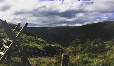
It has a sheltered harbour and lies at the mouth of the River Dun and Glendun, one of the nine Glens of Antrim. The Mull of Kintyre in Scotland is only about 15 miles away across the North Channel and can be seen easily on clear days.

The village was designed by Clough Williams-Ellis in 1912 at the request of Ronald John McNeill, Baron Cushendun. The picturesque Cornish appearance was deliberate, in an effort to please Maud, the Baron’s Penzance-born wife. After Maud’s death in 1925, Ellis designed a row of quaint, whitewashed cottages in her memory, called Maud’s Cottages. Baron Cushendun also commissioned neo-Georgian Glenmona House in eighteenth century architectural style.

One of the 'jewels' of the Glens of Antrim, the conservation village of Cushendun has been protected by the National Trust since 1954. Cushendun's picturesque coastal setting in the heart of the Antrim Coast and Glens Area of Outstanding Natural Beauty, together with its unique architectural inheritance, resulted in designation as a Conservation area in 1980. Centuries before this genteel village was built, Cushendun was a safe landing place and harbour for the frequent travellers between Ireland and Scotland. Rival Irish clans often landed on the beach near Carra Castle. Built in the fourteenth century over a Mesolithic flint site, the ruins of the castle remain today. Close to the ruins lie several Bronze Age standing stones.

Two different walking routes are available allowing visitors to explore all that this compact village has to offer.

CUSHENDUN LONG WALK

From the car park follow the waymarkers around this circular walk. The 1.9 km promoted perimeter pathway consists of pavement (road), grass, gravel, dirt and plastic grid surface and includes a riverside walk.

CUSHENDUN SHORT WALK

From the car park follow the waymarkers around this circular walk.
 

Facilities

Accessibility

  • Toilets for disabled visitors

Catering

  • Picnic Area

Establishment Features

  • Toilets

Parking & Transport

  • Car parking
  • Parking (free)

Map & Directions

What's Nearby

  1. The beautifully restored Old Church Centre offers arts & heritage events, exhibitions,…

    0.08 miles away
  2. Located one mile from Cushendall are the delightful ruins of a 13th century Franciscan…

    2.5 miles away
  3. A lonely and mysterious Moorland Lake, sometimes called the 'Vanishing Lake'.

    3.26 miles away
  1. A 13th century hilltop castle with a couple of names, a commanding view – and a…

    3.88 miles away
  2. Five-mile drive through peatland forest with many fine views of Rathlin Island and…

    4.2 miles away
  3. The ruins of Ardclinis Church and Graveyard occupy a beautiful setting overlooking Red…

    5.14 miles away
  4. A traditional Irish sheep farm experience in County Antrim. Get an insight into sheepdog…

    7.05 miles away
  5. Nestled within the famous Glens of Antrim you can expect a warm welcome at Dunfin, a…

    7.05 miles away
  6. Located within the Slieveanorra and Croaghan Area of Special Scientific Interest (ASSI),…

    8.07 miles away
  7. Glenariff, the Queen of the Glens, is one of the nine Antrim Glens in Northern Ireland.…

    8.09 miles away
  8. Ballycastle Beach offers stunning views of Rathlin Island and Fairhead and is…

    8.85 miles away
  9. Remains of Franciscan friary founded around 1500 by Rory MacQuillan. East range of…

    8.99 miles away
  10. Folk and social history of the Glens in the town's 18th century courthouse. Exhibits…

    9.66 miles away
  11. Breen Oakwood is part of the larger Breen Forest and is one of the last fragments of the…

    10.04 miles away
  12. We specialise in producing smoked foods naturally, in the picturesque coastal town of…

    10.1 miles away
  13. There are two way-marked hill walks at Altarichard on the scenic route between…

    10.45 miles away
Previous Next

Related

section of walking trail on ronan's wayRonan's Way, Northern IrelandRonan’s Way will take you through a truly inspiring landscape, from the Glendun River through farmland, woodland scrub and peatland.

Map & Directions

View Maps and Visitor Guides
View of what Causeway Coast and Glens has to offer and some of the best things to see and do during a visit.
E-newsletter sign up
Sign up for the Causeway Coastal Route newsletter for inspiration and travel tips.
Back to Top

Tourism Northern Ireland

Don't Miss