Book Tickets Online
About
STARTING POINT
The walk can be started at various points on the circuit and walked in either direction. Car parking is available at Dungonnell Dam, in Cargan village, and at the Drum Wood. A way marked route with clear signage at all junctions, the walker is guided smoothly
around.
ROUTE DESCRIPTION
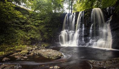
Dungonnell Way is a circular way-marked walking route of approximately 9.5 miles around the Northern part of Glenravel Glen, following tracks and public roads all the way. Car-parking is available at Dungonnell Dam, in Cargan Village and at the Drum Wood. The Dungonnell area lies on the watershed between the source of the Glenariff River, which drops 6 miles north to the sea at Red Bay and the source of the Glenravel Water, which flows south to meet the River Bann and on to Lough Neagh 30 miles away. Beside is Glenariff Forest Park which covers an area of 1185 hectares, of which 900 have been planted with trees. The forest contains spectacular waterfalls. Four other waymarked trails of varying length wind through the forest following a circular route and are signposted from the Forest car park.
POINTS OF INTEREST
Dungonnell is located within the Garron Plateau Area of Special Scientific Interest, designated because of its particular geology and peatland flora and fauna. The area also contains habitat types and species that are rare or threatened within a European context, earning it a further designation as a Special Area of Conservation. Visitors using the path should take extra care to conserve the special plants and animals by neither picking nor disturbing them, and staying to the waymarked route at all times.
The Garron Plateau is the largest area of intact blanket bog in Northern Ireland. Blanket Bogs are characteristically wet under-foot and usually dominated by carpets of bog-moss Sphagnum species, cotton grasses and heathers. The site is rich in rare and notable plants including Narrow-leaved March-orchid, Bog Orchid and Marsh Saxifrage. Other plants grow in abundance including Bog Asphodel, Sun Dew, an insect devouring plant, and Bog Cotton.The Plateau is home to a large breeding population of Red Grouse and it serves as a good hunting ground for Merlin, Peregrine Falcon, Buzzard and Hen Harrier. The area also provides a suitable habitat for Snipe, Curlew, Lark, Teal and Mallard.
Wild animals to be found in the area include fox, hare, rabbit and stoat. Dungonnell Dam was opened in 1971 and provides a water supply for Waterfoot,Cushendall, Cushendun, Glenravel, Clough, Glarryford and parts of Ballymena. Covering 30 hectares when full, the reservoir has a plentiful supply of brown trout.
Facilities
Accessibility
- Activities accessible for visitors with disabilities
Leisure Facilities
- Fishing
Parking & Transport
- Car parking
- Parking (free)