The official website of Visit Causeway Coast and Glens
En

Garvagh Forest Trails

Garvagh Forest, Main Street, Garvagh, Derry/Londonderry, BT51 5NQ
The Pyramid at Garvagh Forest
  • The Pyramid at Garvagh Forest
  • Two walkers with dogs on leads on one of the trails at Garvagh Forest
  • Two cyclists, two walkers and a dog on the Garvagh Forest Trail

Book Tickets Online

About

Garvagh Forest, located on the edge of the town, was formerly part of Lord Garvagh’s Demesne. 

Within the forest there are three waymarked walking trails along the network of forest roads, ranging in distance from 1.3km – 6.9km.  All the trails are circular in nature, starting and finishing in the trailhead car park, and are signed in both directions.  Walkers should be aware there is a number of dedicated mountain bike trails within the forest and that cyclists are also welcome to use all the forest roads within this forest. Cyclists should give way to pedestrians and sound a warning when approaching from behind.  Walkers should keep an eye for animal sculptures located along the trails. The trail head car park accommodates approx. 25 parking bays, including two disabled parking bays, and three picnic tables.  The nearest toilets are located at the nearby Jim Watt Sports Centre, and also in the centre of the town.

All recreational users of this forest are encouraged to follow the ‘Leave No Trace’ principles.  Please respect everyone’s forest experience and enjoy your visit!

The following waymarked walking trails are available within the forest:

Pyramid Trail (1.3 km long / approx. 20 mins) 
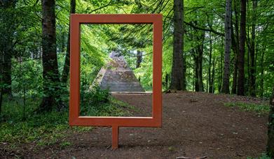
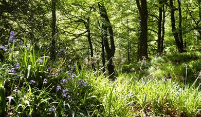
This trail is promoted as an all-ability multi-use trail and is relatively flat over most of its length. The trail edges the Agivey River for approx. half its length and passes through the main bluebell area under a canopy of beech, oak, ash, sycamore and elm trees. It passes the Pyramid within the forest on its return to the car park.

River Trail (5.0 km long / approx. 60 mins) 
This longer trail shares the route of the Pyramid Trail alongside the Agivey River before continuing alongside the Gortree Burn and skirting Rabbit Hill to the centre of the forest.  It passes the Pyramid within the forest on its return to the car park.

Canning Trail (6.9 km long / approx. 80 mins) 
The longest walking trail skirts almost the entire perimeter of the forest, which was formerly part of Lord Garvagh’s demesne. It ventures into quieter parts at the western end of the forest, and affords walkers elevated views of the surrounding landscape in the northern section of the forest. It also passes the Pyramid on its return to the car park.
 

Facilities

Accessibility

  • Designated parking provided for guests with disabilities

Catering

  • Picnic Area

Parking & Transport

  • Car parking

Map & Directions

What's Nearby

  1. Covering 200 hectares, Garvagh forest is situated on the Western outskirts of Garvagh,…

    0.02 miles away
  2. A 200-hectare forest containing many species of trees, wildlife – and even a pyramid…

    0.06 miles away
  3. Nestling on the edge of Garvagh forest, Garvagh Museum is one of the region’s best kept…

    0.19 miles away
  1. Travel 3 miles west of Garvagh town and you will begin to enter Gortnamoyagh Forest,…

    2.13 miles away
  2. The Blackheath Pottery is a unique pottery and café, situated between Coleraine and…

    4.62 miles away
  3. A megalithic tomb, dating to the Neolitic or New Stone Age (2000-4000) is found in…

    4.66 miles away
  4. A beautiful and historically important bridge within tranquil woodland, just outside the…

    6.13 miles away
  5. A picturesque wooded picnic area on the banks of the Lower River Bann – with an important…

    8.28 miles away
  6. In this beautiful setting visitors have time to reflect on the unprecedented achievements…

    9.18 miles away
  7. Ballymoney’s Arts, Museum and Visitor Information Centre is well worth a visit. This…

    9.28 miles away
  8. From the Mesolithic to Motorcycles, through rebellion and war, politics, industry, sport…

    9.29 miles away
  9. Rosepark Farm is a family run attraction spread over 70 acres, situated in the North…

    9.39 miles away
  10. This burial ground is the site of the ruins of the old parish church which was completed…

    9.46 miles away
  11. A striking local landmark, the church tower is the oldest structure in Ballymoney. An…

    9.46 miles away
  12. Mountsandel Wood is the earliest known settlement of man in Ireland dating to between…

    9.5 miles away
  13. A pleasant urban 40-acre Park in the heart of Ballymoney Town, in which to enjoy a…

    9.52 miles away
Previous Next

Related

Frame at Garvagh ForestPicture This: Garvagh Forest, GarvaghA 200-hectare forest containing many species of trees, wildlife – and even a pyramid…

bluebells and woodland at Errigal GlenErrigal Glen, Northern IrelandThis 4km / 2.5 mile long waymarked trail starts and finishes at the Errigal Bridge entrance to Errigal Glen on Temple Road approx. 3 miles south west of Garvagh.

Map & Directions

View Maps and Visitor Guides
View of what Causeway Coast and Glens has to offer and some of the best things to see and do during a visit.
E-newsletter sign up
Sign up for the Causeway Coastal Route newsletter for inspiration and travel tips.
Back to Top

Tourism Northern Ireland

Don't Miss