The official website of Visit Causeway Coast and Glens
En

Croaghan Way

Altarichard Road, Ballymoney, Antrim, BT53 8XT
Croaghan mountain
  • Croaghan mountain
  • bogland on Croaghan Way
  • bogland and signage on Croaghan Way
  • bogland on Croaghan Way
  • signage at Altarichard Viewing Point

Book Tickets Online

About

STARTING POINT

Located at the Altarichard car park/viewing area on the Orra Scenic Drive between Magherahoney and Cushendall/Cushendun.

ROUTE DESCRIPTION

The Croaghan Way incorporates two self-guided trails; the ‘Milibern Walk’ and the longer ‘Breen Forest Walk.’ The trail exists by way of an access agreement between Council and the landowners, Blakiston-Houston Estates, with the cooperation of the Forest Service. The Croaghan Way was established in the 1990s, before the Slieveanorra and Croaghan ASSI designations on 11th March 2009. This makes the area very special as one of only a few accessible designated upland blanket bogs in Northern Ireland.

To ensure the peatland remains largely undisturbed it is vital that walkers keep strictly to the waymarked routes.

POINTS OF INTEREST

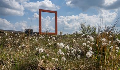
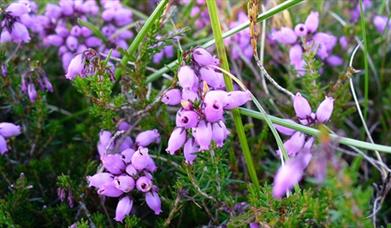
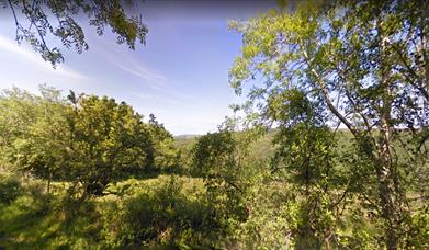
The Croaghan Way takes you through some of the best blanket bog, which is recognised by its designations national, Slievanorra and Croaghan Area of Special Scientific Interest (ASSI) and at European level, Antrim Hills Special Protection Area (SPA). It is an area of largely intact blanket bog, which means the peat lies like a blanket over the hill. There are areas of bog pools where you will see plants like sphagnum, bog bean and aquatic bog mosses. Other plants you should see as you walk along are bog asphodel, and both round-level sundew and great sundew. Much of the bog is dominated by heather, cross-leaved heath, hare’s-tail cotton grass, crowberry and bilberry. This area of bog provides an important habitat for upland birds, especially merlin and hen harriers which breed near-by and use the area for feeding. Other birds you may see are snipe, red grouse and raven. Common lizards have also been seen here. Panoramic views of Rathlin Island can be experienced from Croaghan.

Facilities

Catering

  • Picnic Area

Parking & Transport

  • Parking (free)

Map & Directions

What's Nearby

  1. Located within the Slieveanorra and Croaghan Area of Special Scientific Interest (ASSI),…

    0.01 miles away
  2. A traditional Irish sheep farm experience in County Antrim. Get an insight into sheepdog…

    3.32 miles away
  3. This beautiful avenue of beech trees was planted by the Stuart family in the eighteenth…

    6.01 miles away
  1. A lonely and mysterious Moorland Lake, sometimes called the 'Vanishing Lake'.

    6.62 miles away
  2. Folk and social history of the Glens in the town's 18th century courthouse. Exhibits…

    6.98 miles away
  3. Remains of Franciscan friary founded around 1500 by Rory MacQuillan. East range of…

    7.11 miles away
  4. We specialise in producing smoked foods naturally, in the picturesque coastal town of…

    7.21 miles away
  5. Glenariff, the Queen of the Glens, is one of the nine Antrim Glens in Northern Ireland.…

    7.23 miles away
  6. With the towering Lurigethan Mountain rising behind the village and Glenballyeamon…

    7.31 miles away
  7. Ballycastle Beach offers stunning views of Rathlin Island and Fairhead and is…

    7.49 miles away
  8. Located one mile from Cushendall are the delightful ruins of a 13th century Franciscan…

    7.59 miles away
  9. A 13th century hilltop castle with a couple of names, a commanding view – and a…

    7.64 miles away
  10. Waterfoot Beach is a wide, golden stretch of sand that offers a peaceful retreat along…

    7.72 miles away
  11. The beautifully restored Old Church Centre offers arts & heritage events, exhibitions,…

    8.02 miles away
  12. With its sweeping views, gently lapping waves, and quaint storybook surroundings, this…

    8.12 miles away
  13. Kinbane Castle is a Historic Monument sited in the townland of Cregganboy, located along…

    9.2 miles away
Previous Next

Related

Frame on Altarichard Point Picture This: Altarichard Frame, Northern IrelandLocated within the Slieveanorra and Croaghan Area of Special Scientific Interest (ASSI), this is one of the few accessible upland blanket bogs in Northern Ireland.

Purple flowers at Breen OakwoodBreen Oakwood Nature Reserve, Northern IrelandBreen Oakwood Nature Reserve Walk is a 1.7 mile lightly trafficked loop trail located near Ballymoney, Antrim, Northern Ireland and is good for all skill levels. The trail is primarily used for hiking, walking, nature trips, and bird watching.

Moyle WayMoyle Way, Northern IrelandTaking the walker through a magnificent land of geology, wildlife, history and folklore, this route passes a wealth of rivers, ancient monuments and exposed hill summits before reaching its end in the beautiful Glenariff Forest Park. 

Map & Directions

View Maps and Visitor Guides
View of what Causeway Coast and Glens has to offer and some of the best things to see and do during a visit.
E-newsletter sign up
Sign up for the Causeway Coastal Route newsletter for inspiration and travel tips.
Back to Top

Tourism Northern Ireland

Don't Miss